



Flow measurement specialist NIVUS has developed a wireless river monitoring system designed to provide continuous flow data without the need for cross-river cabling.
The Wireless Transit Time system uses satellite timing and wireless communication between riverbanks, offering water managers and regulators a less invasive alternative to traditional cabled transit-time river flow monitoring.
River flow data is central to flood warning, modelling, forecasting, water resources planning and abstraction management. In England, the Environment Agency’s hydrology data services support monitoring of river flows, levels, rainfall and groundwater across national networks.
NIVUS said the new approach has been developed to retain the accuracy of transit-time flow measurement while reducing the cost, complexity and environmental disruption associated with installing cables or ducts across river channels.
Why River Flow Monitoring Matters
River flow measurements support a wide range of water management decisions, from flood risk planning to the management of water abstraction licences. They also help regulators track long-term changes in catchments, including the impacts of climate change on river systems.
According to the Environment Agency, its hydrometric monitoring points dataset covers sites used to monitor water quantity, including rivers, groundwater, lakes, estuaries and rainfall.
“The measurement of river flow in England presents a particular set of challenges,” said Sam Everitt, National Hydrometry Advisor at the Environment Agency. “We monitor everything from slowly responding lowland rivers to catchments that can experience rapid changes in flow during storm events.”
“This means that flow monitoring technology has to be sufficiently robust and versatile to perform reliably across a wide range of river conditions.”
How Transit-Time Flow Monitoring Works
Transit-time flow measurement is a standard method used to measure river and open-channel flow. The technique relies on acoustic signals travelling between sensors positioned on opposite banks.
Sound waves travel faster with the direction of flow and slower against it. By measuring the difference between upstream and downstream signal transmission times, the system calculates flow velocity across the river channel.
Unlike spot velocity measurements, a multi-path transit-time system can provide a fuller velocity profile of the river. NIVUS says the method can be applied to rivers up to 200 metres wide, with multiple sensors and signal paths used for deeper water or more complex monitoring requirements.
“We can apply this method to a wide range of channel sizes, and for rivers up to 200 metres wide,” said Alistair MacKinnon of NIVUS. “Deep water can also be accommodated with multiple sensors and signal paths.”
Removing The Need For Cross-River Cabling
Traditional transit-time systems usually require sensors on both banks to be connected by cross-river cabling. This can involve civil engineering works, cross-ducting on the riverbed, or cables attached to bridges or other infrastructure.
These installations can be expensive and disruptive, particularly on sensitive rivers or remote sites. Riverbed ducting may also create ecological impacts, interfere with human activity or be damaged during severe weather.
The NIVUS Wireless Transit Time system replaces the cross-river cable connection with Wi-Fi communication between sensors, while GPS/GNSS satellite timing keeps the equipment synchronised to nanosecond-level accuracy.
The system can also be powered by solar panels and batteries, enabling deployment at off-grid monitoring locations. NIVUS says ground screws can be used to anchor bankside equipment, reducing the need for concrete and simplifying decommissioning.
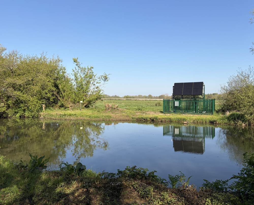
NIVUS WTT flow monitor on the River Ouse at Barcombe Mills.
External Links
River Ouse Installation At Barcombe Mills
A NIVUS Wireless Transit Time system has recently been installed on the River Ouse at Barcombe Mills, close to Barcombe Reservoir in East Sussex.
The new system replaced an older cabled transit-time monitor that had failed. The Environment Agency and its predecessor, the National Rivers Authority, have monitored river flow at the site for more than 30 years.
The previous installation used a cross-river duct laid on the riverbed and weighed down by clay chimney pots. Replacement options included boring a tunnel beneath the river or installing new cross-river ducting, but both raised cost, practicality and environmental concerns.
“It would be possible to bore a tunnel under the river, but this requires tunnelling to begin at some distance from the river to create the correct angle of bore,” said Theo Parfitt from the Environment Agency’s regional Hydrometry & Telemetry team.
“However, aside from the high cost, the proximity of the reservoir rendered this option redundant. Similarly, replacement of the cross-river ducting was disregarded because of cost and environmental issues.”
At Barcombe Mills, the River Ouse is approximately 20 metres wide. NIVUS estimated that the wireless system would cost around 25% of the cost of a ducted system. Existing submerged sensor racks on both banks were also reused, helping to reduce project costs.
Future Use In River Monitoring
The Environment Agency already operates two wireless transit-time systems in North London and Yorkshire. The Barcombe Mills installation is the first of these NIVUS systems to be fully solar powered.
“This is a good example of the ways in which the Environment Agency can leverage its size and expertise, working with specialist partners, to develop innovative solutions that save money and enhance environmental protection,” said Everitt.
“Given these advantages, we are looking to switch our existing Transit Time monitors to wireless versions as they come up for renewal. The new technology appears to be working very well, and has prompted interest from our counterparts in North America and Scandinavia.”
NIVUS said the technology could support flood protection, abstraction monitoring, waterway management, ecological monitoring and long-term river catchment analysis.
FAQs
What is wireless transit-time river flow monitoring?
Wireless transit-time river flow monitoring is a method of measuring river flow using acoustic sensors on opposite banks. Instead of connecting those sensors with cables across the river, the system uses wireless communication and satellite timing.
Why does removing cross-river cabling matter?
Removing cross-river cabling can reduce installation costs, avoid disruptive riverbed works and make it easier to install monitoring systems at hydraulically suitable locations rather than only where bridges or ducts are available.
Where has the NIVUS system been installed?
A NIVUS Wireless Transit Time system has been installed on the River Ouse at Barcombe Mills in East Sussex, replacing an older cabled transit-time monitor.
How is the Barcombe Mills system powered?
The Barcombe Mills installation is fully solar powered, allowing it to operate without a mains power supply.
What is river flow data used for?
River flow data supports flood forecasting, water resources planning, abstraction licence management, environmental monitoring and long-term assessment of catchment and climate change impacts.


