When it comes to hydrology, Nebraska has it all – great regional disparities in precipitation, large rivers and permeable sandy soil making for a good supply of groundwater. In terms of variance of precipitation, the western end of the state is in the high plains with an annual average of only 13” of rain, meaning they rely on the snowmelt and a system of reservoirs from Colorado and Wyoming to make up the difference in water demand. The eastern end of the state has an annual rainfall of 33” which is almost enough precipitation to take care of all the agricultural irrigation. There are many irrigation districts in Central Nebraska that rely upon Lake McConaughy which is fed by the North Platte River.
On average, 90 million acre feet of rain falls on Nebraska, 2 million acre feet of water flows into Nebraska through streams and rivers, and 9 million acre feet flows out of the state. Monitoring where all this water goes is a vital role and responsibility of the Nebraska Department of Natural Resources (NeDNR). Different groups throughout the state have ownership rights on much of the water that passes through, so having regular up-to-date measurements is necessary for accountability.
Nebraska is a large agricultural state and leads the nation in irrigated acres. NeDNR works in partnership with many other organizations in sharing and receiving data and accumulating enormous amounts of their own data. Turning this information into timely, reliable insights is where the rubber hits the road.
In the early 2000’s, NeDNR was running a state-of-the-art database for its time that was fully meeting their needs. Migration to a new domain, security improvements, and a loss of in-house IT and local PC support changed all of that.

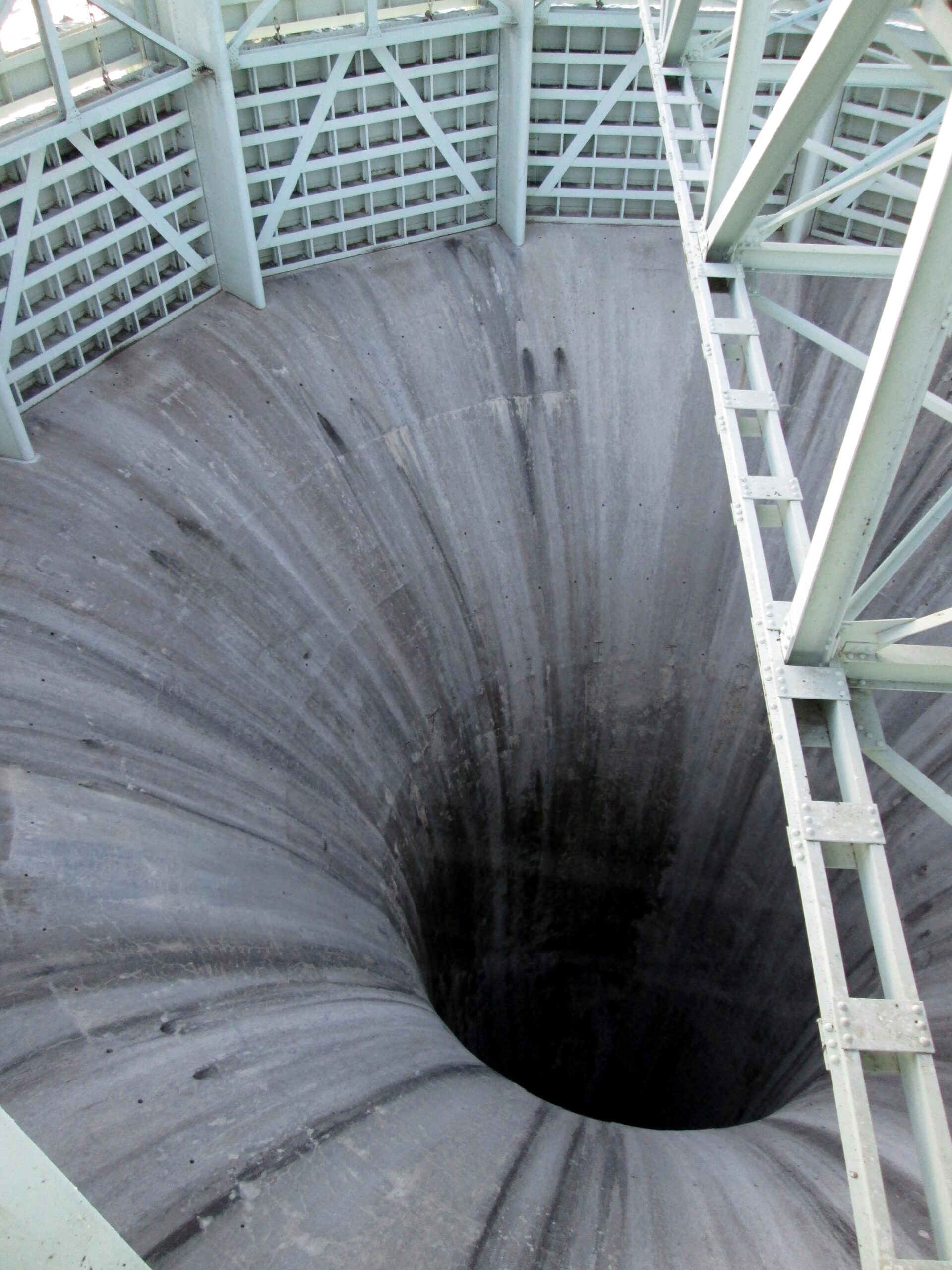
Looking down the 30 m throat of the Kingsley Dam Primary Spillway
NeDNR wanted to modernize and move to a virtual server to improve performance efficiencies across offices in 2014 but ran into several complications.
James Williams, Stream Gaging Engineer of Nebraska Department of Natural Resources & NE Rain, remembers one such incident. “There were all kinds of technical glitches that kept setting us back, with no logic to the root cause of the problem, so we were band-aiding problems as they came up. For example, our system would shut down every Friday between 5 and 6 pm. There was no reason that this time of day should be any different than the other days of the week, if anything there was less traffic at this time. We figured out a way to fix the issue by making calls from the server to our display page every hour in order to keep it live over the weekend.”
The system was improved by going to a binary database and no longer saving some massive log files, which both helped speed up the program. However, the system kept failing 1-2 times a week and after a year of more than 75 system failures in 2018 Jeremy Gehle, Head of Water Administration for Nebraska Department of Natural Resources, reached out to neighboring states and the USGS Water Science Center.
Gehle recounts, “They were all having success with the Aquarius platform and suggested we do a trial running it on one of our State servers, which we did, and it worked right from the get-go.” Aquarius software is used by water monitoring agencies around the world to acquire, process, model and publish information in real-time.
“Transitioning software platforms is never easy. That said, our USGS counterpart said that while any transition is hard after a year of working with the system we wouldn’t go back – this of course gave us a good level of confidence to make the move,” said Gehle.
Nebraska’s stream gaging program has 250 sites that include continuous stream and reservoir gages, partial year gages, canal gages, canal return flow gages, and various spot measurements. The core network consists of approximately 110 continuous stream gages and 120 canal gages. With extreme flooding events over the last few years, it is vital that the data collected by NeDNR be accurate, reliable and timely.
“You know how valuable your service is when you get calls from the National Weather Service or the Army Corps of Engineers asking you to check your gages because the data is not coming through. These organizations are watching our stream gages because it is vital for forecasting flooding,” said Gehle.
The Aquatic Informatics team who developed Aquarius, performed a business analysis with NeDNR’s staff to map the data migration and better understand their data workflows. Through the process, they uncovered several areas for improvement in their data management workflows. The modern enterprise architecture automated some former manual processes and simplified data computation steps.
“We appreciated the support in setting it up with our network and were pleased with the level of continuity and logging of queries to overcome issues. We felt a strong level of technical guidance from Aquatic Informatics that made the transition easier than we expected,” said Gehle.
The new software makes it easy to integrate, import, and enter data quickly and securely while storing all information in one central place, making management and reporting more streamlined. The program also automates the quality assurance of data with tools for error detection, data cleaning, data flagging, and automatic bias corrections.
The reliability and streamlining of processes with the new software have enabled NeDNR to get all their records up to date when they were often months behind. With so much data collection on a daily basis, managing this information can be an enormous task without effective tools. “At one point in time, we had a five-year backlog of hydrographic reports for some of our stations. Aquarius is user-friendly which makes it easier for our field hydrologists to stay on top of data entries, consequently, we are now completely up to date on reporting. By keeping on top of daily data, our hydrologists are more likely to note any action items that need to be addressed, meaning we can do a better job,” said Williams.
Jim Marburger, the Natural Resources Specialist Supervisor at Nebraska Department of Natural Resources, said, “The new program makes it easier to find all the information you need in one place. If you are looking for a measurement or level, you can easily find it in the system—along with related comments—and not have to go out to a different server residing in a field office. This has improved our workflow and saves time in reviewing and reporting, so we can now focus that time elsewhere.”
It’s not unusual to have compatibility issues with different software systems. As the trend moves towards cloud native applications for the obvious advantages of accessibility and security, the newer software is designed to streamline integration across departments for holistic management of all water resources. With such a rich and diverse hydrological landscape and heavy reliance on their data and services by stakeholders, NeDNR knows it’s imperative to have a reliable state-of-the-art data management platform. By removing menial data entry and downtime, the hydrologists and other skilled workers can now do more community outreach and analysis for new and improved decision-making to better serve their stakeholders.
Related articles:
Southern California prepared for drought with investments in storage, conservation and diverse supplies
Utilities believe that polyethylene piping materials and trenchless technology are key to overcoming water loss


